GlobalCORRIDOR #14
Mapping the Corridor Geographies of the Belt and Road Initiative

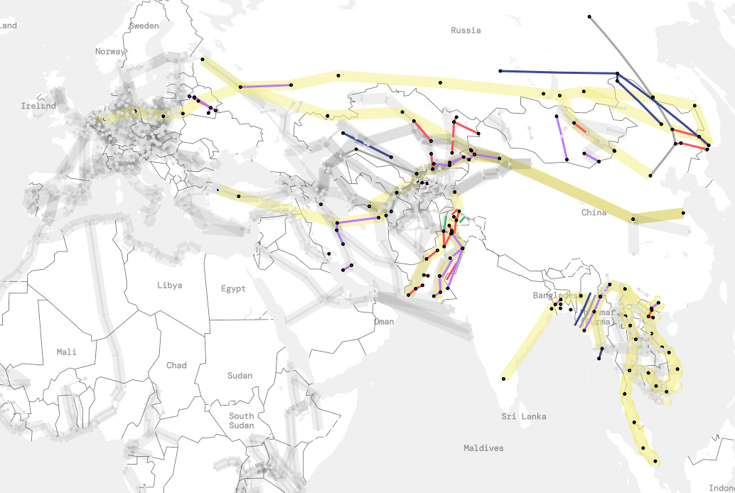
Dear readers, this newsletter is written with project colleague, Zhengli Huang and introduces our research assessing the corridors of the Belt and Road Initiative (BRI), which are now fully included in the beta version of our GlobalCORRIDOR Atlas (accessible here). The dataset incorporates 233 infrastructure projects encompassing $551.7 billion of investment. The BRI is perhaps the most prominent collected set of infrastructure investments on the planet and a key driver of the corridorisation of territories in recent years. It has, at least partly, been ordered through six corridors, however the precise geographies remain rather vague (and many investments are being implemented beyond these corridors, tracked by organisations such as China AidData). As part of our wider Atlas work we’ve dedicated significant research effort to attempting a more accurate assessment about each of these corridors and the investments that constitute the making of them. Below you can read more about each corridor, the approach we’ve taken and some early observations. As with the rest of the data in the beta version we’re keen to get your feedback before making some final decisions and moving on to some detailed analysis about financing, contractors, costs and other interesting data that has been collated.
We’ve got detailed case study work starting to emerge on some of the projects relating to the China Pakistan Economic Corridor through our long term collaboration with the Karachi Urban Lab incorporating railways, real estate developments and manufacturing zones. If you want to read more project outputs relating to the BRI you can also find our edited book ‘Material Geographies of the BRI’ published open access with Bristol University Press, as well as a accompanying paper in Urban Geography journal ‘Cities on the New Silk Road’, both written and edited with Elia, Han and Alan. For now we’re excited to present our interpretation of the corridor geographies of the BRI…
Introducing the BRI’s Six Infrastructure Corridors
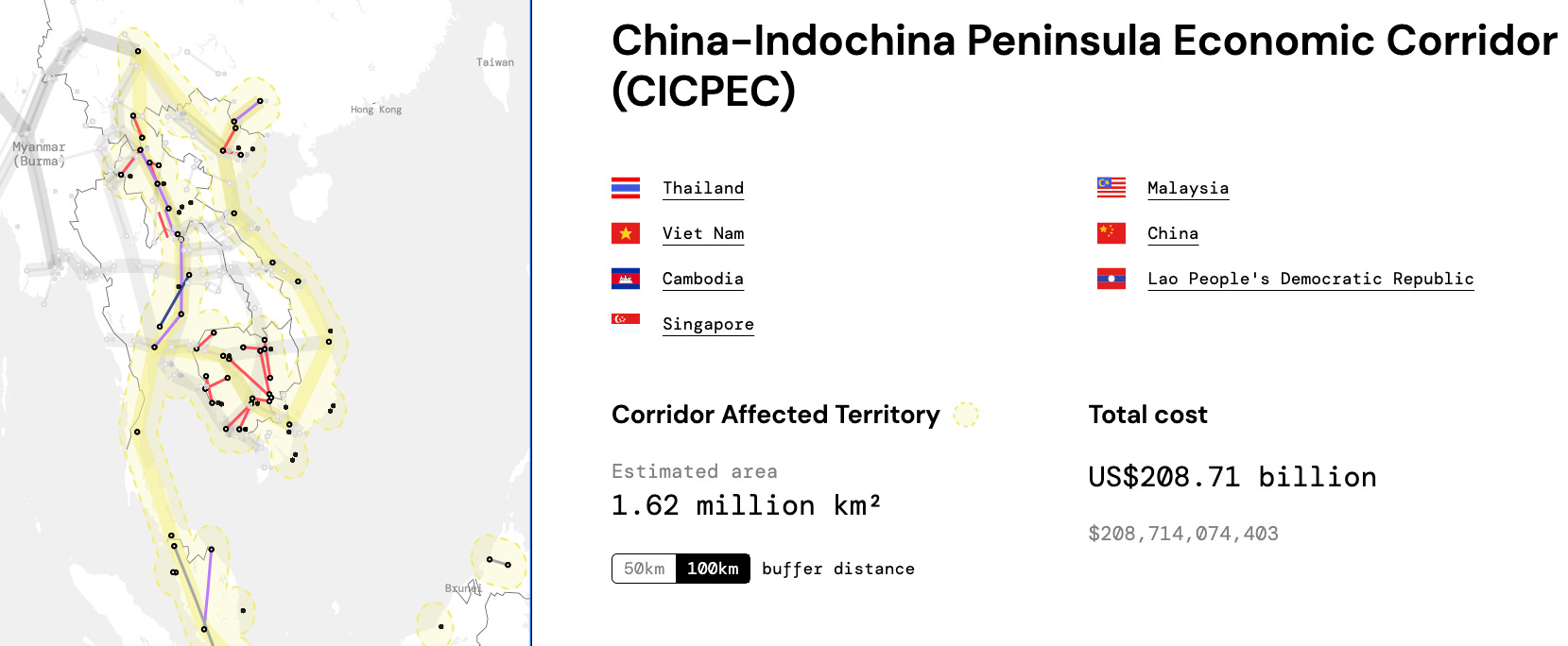
The China–Indochina Peninsula Economic Corridor (CICPEC) is a southern axis of the Belt and Road Initiative that connects southwestern China to mainland Southeast Asia. Linking China’s Yunnan and Guangxi regions to the Mekong subregion, the corridor spans Vietnam, Laos, Cambodia, Thailand, and Malaysia, extending toward Singapore. Its structure is organised around several north–south alignments radiating from Kunming and Nanning, converging through key regional hubs such as Hanoi, Vientiane, Bangkok, and Phnom Penh. The corridor builds upon and overlaps with earlier regional integration frameworks, particularly the Greater Mekong Subregion (GMS) economic cooperation programme.
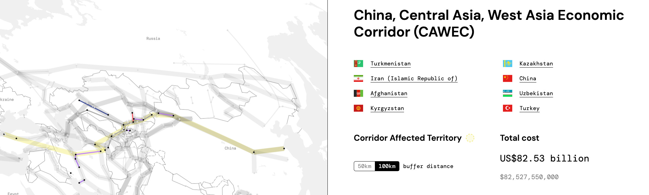
The China–Central Asia–West Asia Economic Corridor (CAWEC) is a key overland axis of the Belt and Road Initiative that links ports in Eastern China to Europe and the Middle East through Central Asia. Like the New Eurasian Land Bridge (NELB) and the China–Mongolia–Russia Economic Corridor (CMREC), the China–Central Asia–West Asia Economic Corridor (CAWEC) follows one of the principal alignments of the China–Europe Railway Express network. As a key component of the Belt and Road Initiative, it is structured as a multi-modal corridor of railways, dry ports, and maritime links rather than a single linear route.
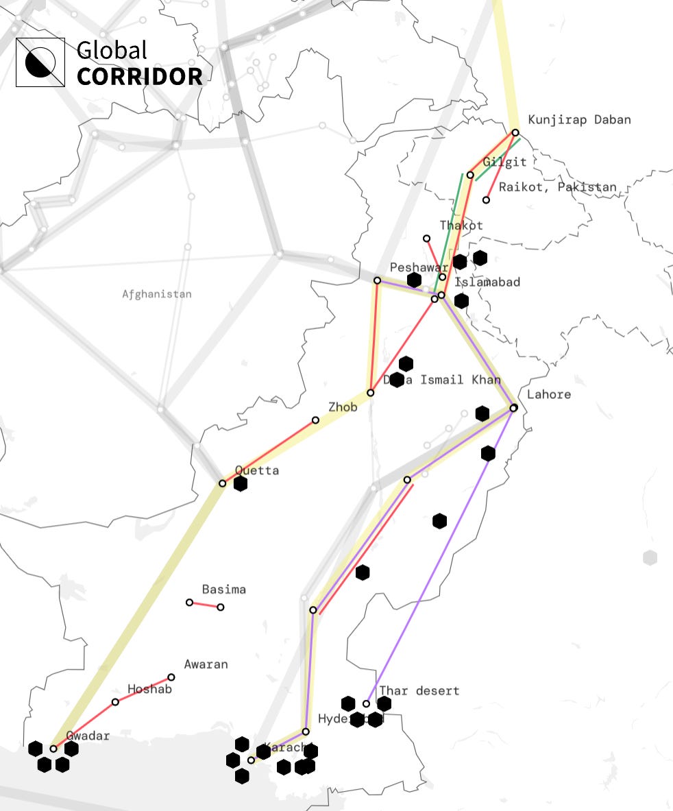
The China-Pakistan Economic Corridor (CPEC) is a large-scale infrastructure project and a framework for regional connectivity between China and Pakistan. It’s a key part of the BRI, aimed at boosting trade and investment, and improving infrastructure within Pakistan. CPEC also benefits other countries in the region, including Central Asia, the Middle East, and even parts of Africa. The primary objective of the CPEC is to ramp up Pakistani economic growth, primarily through infrastructure development, energy projects, and industrial collaboration. It has already had a significant effect on Pakistan’s infrastructural geography, with notable investments including Gwadar Port, a huge array of energy generation projects and a new wave of special economic zones. The GC newsletter previously featured an introduction to the CPEC that you can read here.
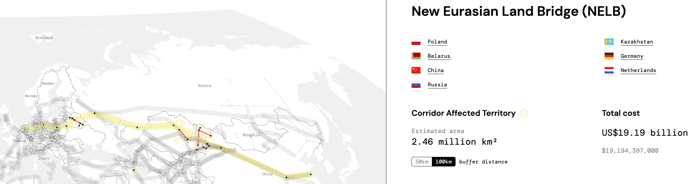
The China-Europe Railway Expressway network functions as the main anchor for the New Eurasian Land Bridge (NELB) Corridor. Building on this freight rail system, the NELB links eastern and central Chinese logistics hubs to Europe via Xinjiang, Central Asia, and the Eurasian rail system. It is important to note that BRI economic corridors are not merely a sequence of straightforward infrastructure projects. Instead, they serve as a cooperation platform for countries to participate in bilateral investments. Consequently, much of the financial cooperation is not captured in this infrastructure-focused atlas. For example, Chinese banks have invested billions of dollars in purchasing shares of wind farms in Poland, which does not necessarily lead to substantial projects.
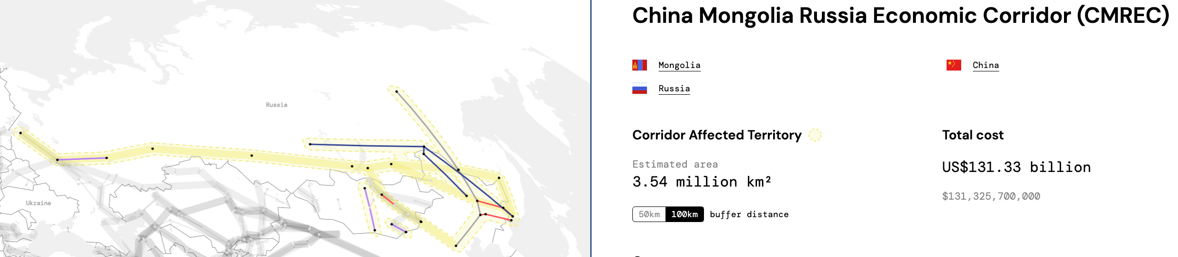
The China–Mongolia–Russia Economic Corridor (CMREC) is a northern overland axis of the Belt and Road Initiative that links Northern China to Russia’s Far East and onward to Europe. Like the New Eurasian Land Bridge (NELB) and the China–Central Asia–West Asia Economic Corridor (CAWEC), the China–Mongolia–Russia Economic Corridor (CMREC) follows one of the principal alignments of the China–Europe Railway Express network. Rather than a single linear route, it is structured as a multi-modal corridor composed of interconnected railways, border ports, and logistics hubs, combining the Trans-Mongolian line (via Ulaanbaatar) with feeder routes from the Russian Far East (via Vladivostok, Khabarovsk, and Chita) that converge into the Trans-Siberian corridor. This configuration highlights CMREC’s role not only as a trilateral development framework but also as a key interface between inland Eurasian rail systems and Pacific maritime gateways.
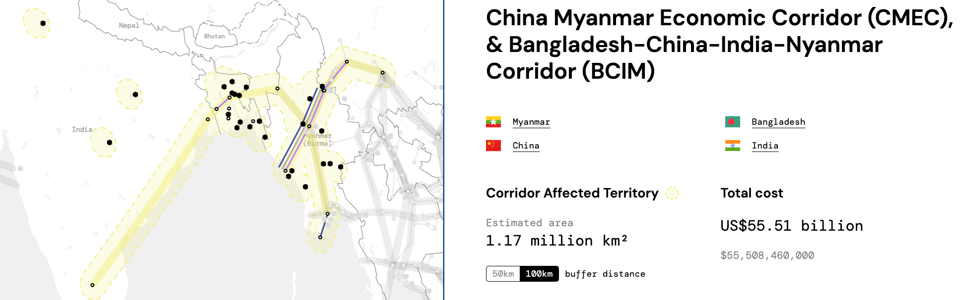
The China–Myanmar Economic Corridor (CMEC), presented in the Atlas in conjunction with the earlier Bangladesh–China–India–Myanmar Economic Corridor (BCIM), links China’s Yunnan Province to the eastern Indian Ocean. While BCIM was initially conceived as a multilateral corridor connecting China, Myanmar, Bangladesh, and India, its implementation has stalled due to geopolitical constraints. In practice, CMEC has emerged as a more operational bilateral configuration, centred on infrastructure development between China and Myanmar. The CMEC is structured around an inverted Y-shape: extending from Kunming to Mandalay, and branching southward to Yangon and westward to Kyaukphyu on the Bay of Bengal. The now-discontinued BCIM framework was expected to extend this route westward from Mandalay across Myanmar into Bangladesh and eastern India, forming a continuous overland connection to the Bay of Bengal.
Our Mapping and Analysis of the BRI’s Infrastructure Corridors
Zhengli, who has led the data collection, technical verification and mapping process has written a first reflection on our mapping and initial analysis of the BRI infrastructure corridors
The Belt and Road Initiative (BRI) is a global framework through which the Chinese government promotes infrastructure development, economic connectivity and international cooperation. The initiative developed from the “Silk Road Economic Belt,” proposed in 2013. The idea was subsequently grouped under the label “One Belt, One Road” and later reframed as the Belt and Road Initiative.
BRI is organised around six major overland corridors: the China–Pakistan Economic Corridor, the New Eurasian Land Bridge, the China–Mongolia–Russia Economic Corridor, the China–Central Asia–West Asia Economic Corridor, the China–Indochina Peninsula Economic Corridor, and the Bangladesh–China–India–Myanmar Economic Corridor. Maritime routes connect these continental pathways to ports across the Indian Ocean, the Mediterranean and other regions. Yet these corridors should not be read as fixed infrastructural programmes comparable to formally governed regional development corridors. The BRI lacks a single, comprehensive planning document that specifies authoritative alignments, project lists, implementation stages and governing institutions. Official texts instead repeatedly describe an open platform through which participating countries identify and construct projects collaboratively.
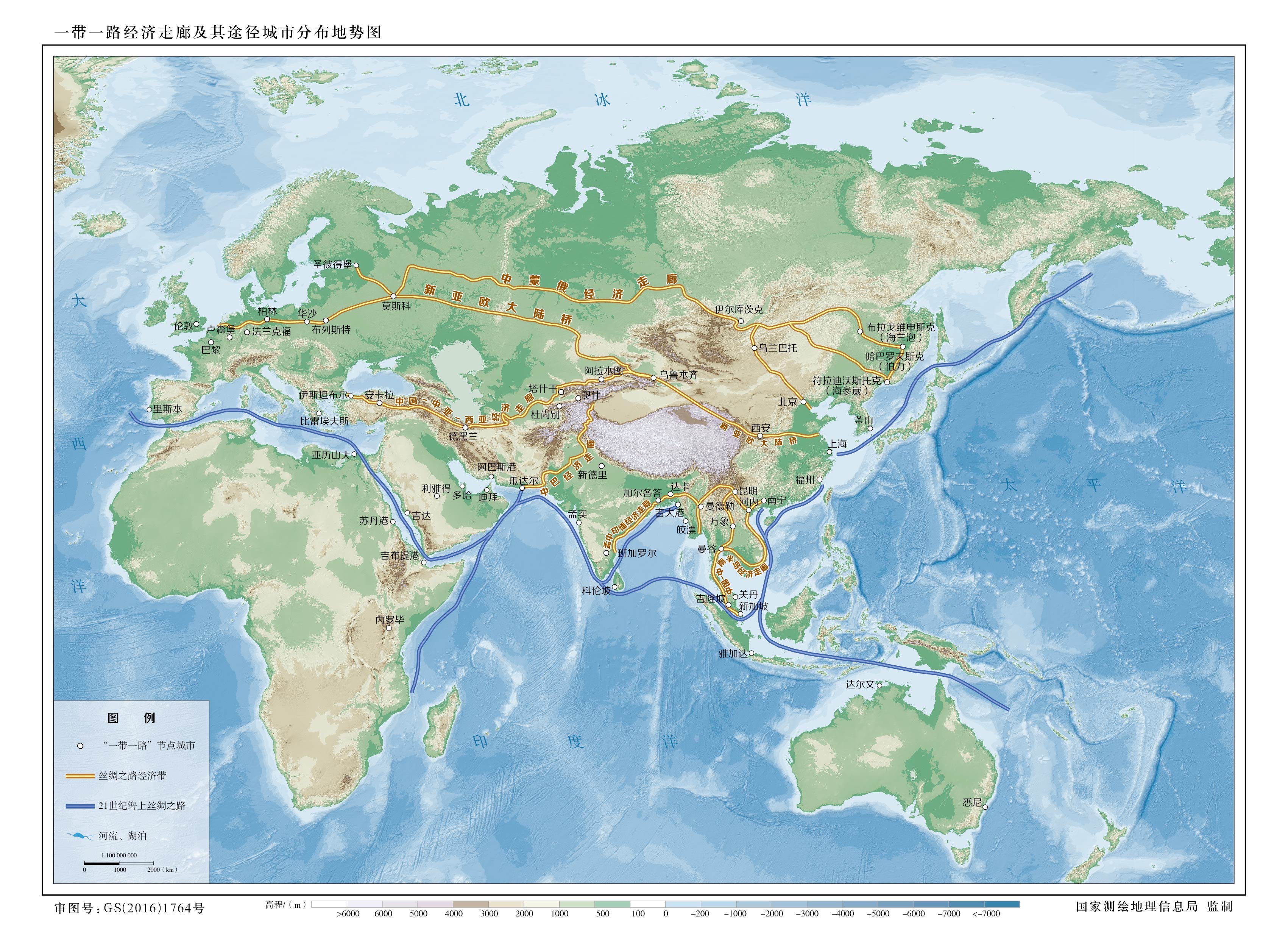
The most definite cartographic expression of this geography appeared in a 2016 map produced by China’s national surveying and geographic-information authorities. It presented six linear land routes and two maritime Silk Road routes. GlobalCorridor adopts this map as its baseline because it offers the clearest official spatial representation available. Even so, the mapped lines are treated as analytical guides rather than precise boundaries.
The changing relationship between the Bangladesh–China–India–Myanmar Economic Corridor (BCIM) and the China–Myanmar Economic Corridor (CMEC) illustrates this institutional fluidity. BCIM was initially conceived as a multilateral corridor linking China’s Yunnan Province with Myanmar, Bangladesh and eastern India, thereby extending an overland connection towards the eastern Indian Ocean. Its implementation subsequently stalled amid geopolitical tensions and India’s wider reservations about the BRI. In its place, CMEC has emerged as a more operational bilateral configuration between China and Myanmar. It is commonly represented as an inverted Y-shaped corridor running from Kunming to Mandalay and then branching southwards to Yangon and westwards to Kyaukphyu on the Bay of Bengal. The earlier BCIM vision would have extended westwards from Mandalay across Myanmar into Bangladesh and India. Presenting BCIM and CMEC together therefore makes visible both continuity and contraction.
GlobalCorridor reconstructs the BRI’s project geography through a staged process. First, we identify the principal cities located along the official corridor routes and determine the countries through which each route passes. These countries are then used to filter the AidData Global Chinese Development Finance dataset. A further sectoral filter is applied to identify potential infrastructure projects. Second, we examine project titles and narratives record by record to distinguish physical infrastructure from financial transactions that do not correspond to a discrete spatial project. We consolidate such records around the underlying physical project while preserving the links to every relevant AidData identifier and financing commitment. AidData provides the principal starting point because it remains the most extensive global source on overseas development finance from Chinese state institutions. Third, we conduct an external audit to identify omissions and verify the information recorded by AidData. This involves checking official government, lender, developer and contractor materials, alongside reliable secondary sources. The resulting atlas therefore uses AidData as an authoritative bridge to Chinese financial flows, but does not assume that its transaction-centred structure corresponds directly to the geography or lifecycle of infrastructure.
Investment and implementation characteristics
Across the corridors examined by GlobalCorridor, the BRI accounts for the largest volume of infrastructure finance and contains an unusually high concentration of megaprojects. At the same time, the project landscape does not display the coherence implied by schematic corridor maps. Railway networks and cross-border connections are often articulated in ambitious regional terms, yet relatively few have been realised as continuous multilateral systems. Most implemented projects are bilateral, negotiated between China and an individual host state and commonly delivered by a Chinese state-owned enterprise. In this sense, the BRI operates not only as a connectivity agenda but also as a mechanism for directing Chinese capital, construction capacity, technology and production into new geographical markets.
This bilateral and project-based mode of implementation also produces significant political vulnerability. Numerous BRI projects have become controversial, stalled or been renegotiated because of changes in host-country governments, local opposition, fiscal pressures, land conflicts or deteriorating bilateral relations. Such outcomes are not anomalies outside an otherwise coherent plan; they are partly generated by the BRI’s flexible governance structure, in which projects are assembled through uneven national institutions and shifting political bargains.
The sectoral composition of the BRI further distinguishes it from corridor programmes centred more narrowly on transport connectivity. Especially across Asia, the initiative includes extensive investment in power generation, mineral extraction, oil and gas pipelines, refineries and other resource-related infrastructure. Transport facilities remain fundamental, but they are embedded within a broader resource- and energy-intensive development model. The BRI consequently connects territories not only by moving people and goods, but also by securing energy supply, enabling commodity extraction and reorganising the infrastructures through which resources are processed and circulated.
Financing has historically depended heavily on lending from China’s policy banks, particularly the Export–Import Bank of China and China Development Bank, supplemented by large Chinese commercial banks and, in some cases, equity investment by state-owned enterprises. Collaboration with multilateral development banks and with public financial institutions from Japan, Korea and other countries occurs, but remains comparatively occasional. More recently, large-scale lending by Chinese banks has slowed, contributing to a shift towards smaller projects, refinancing, risk-sharing arrangements and more selective investment. The BRI should therefore be understood as an evolving mode of international economic engagement rather than a completed spatial blueprint.